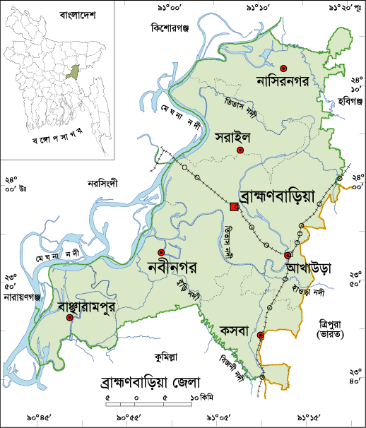
Brahmanbaria District Information
Brahmanbaria District, Bangladesh
Brahmanbaria district is located in the eastern part of Bangladesh. Once the region was a part of Samatat state. Later it was included in Tripura district in 1790. The first and temporary capital of Isa Khan was at Sarail, 10 km north of Brahmanbaria Town. Swadeshi movement (1905), Peasant movement (1930) No-rent movement, War of Liberation Movement (1971) etc are the remarkable chapters of the region. Brhamanbaria was promoted as a municipality in 1869. After the liberation of Bangladesh Current Brahmanbaria was declared as a district in 15 February 1984. Before, the region was included in Comilla district. The Geo position of the district is between 23˚29’ to 24˚16’ North latitudes and between 90˚39’ to 91˚21’east longitude.
Bordered By: Brahmanbaria District is bordered by Kishoreganj andHabiganj district to the north, Comilla district to the south, Habiganj district and Tripura (Indian State) to the east, The Meghna River and a part of Kishoreganj, Narayanganj and Narsingdi districts to the west.
Administration: The area of Brahmanbaria is 1881.20 Sq Km. It is under Chittagong Division. There are 04 Municipalities in Brahmanbaria named Brahamanbaria, Ashugonj, Nabinogor and Kasba. The number of Upazilla (sub district) in Brahmanbaria district is 09, named- Brahamanbaria, Akhaura, Kosba, Bangarampur, Sarail, Nabinagor, Nasirnogor, Ashugonj and Bijoy Nagor containing 100 Unions, 900 Mauzas and 1323 Villages.
Population: The total population of Brahmanbaria district is 28,40,498 (Male- 13,66,711 and Female- 14,73,787), sex ratio is 93:100, population density 1510/Sq Km and annual growth rate is 1.68%.
Literacy: The Literacy Rate of Brahmanbaria district is 45.30% (Male- 45.7% and Female- 44.90%). School attendance rate is 50.80% for 5 to 24 years age group.
Other Important Data: The postal code of Brahmanbaria district is 3500 and NWD Code is 0851. Total Parliament seat in Brahmanbaria is 06. During the liberation war, Brahmanbaria was under Sector Number 02 & 03. Average rainfall of the district is 78.06 cm urbanization rate of the district is 15.79%. Average rainfall of the region is 187 cm.
Rivers: Meghna, Titas, Shalda, Hawra, Pagla, Putia, Sonai, Hawra, Ropa, Buri, Bizna, Balua, Bolak, Dholbanga etc.
Agro Products: Paddy, Jute, Mastered, Onion, Garlic, Pulses, Pine-Apple, Vegetables etc.
Remarkable Personalities from Brahmanbaria District
Addyata Mollobormon (Novelist), Ostad Ayet Ali Kha (Musical Talent), Ostad Alauddin Kha (Musical Talent), Nawab Syed Shamsul Huda, Samaul Hoque (Poet), Ostad Khadem Hossain Kha (Music Personality), Haralal Roy (Writer), Ma Anyandamoye, Sayed Samsul Huda (Educationist), Oli Ahad (Language Fighter), Al Mahmud (Poet), Ali Imam (Literate Personality), Sayad Abdul Hadi (Singer), Safic Rehman (Editor), Subol Das (Composer), Alamgir (Film Actor), Abdul Kadir (Poet) etc.
Famous Tourist attractions in Brahmanbaria District
Titas Gas Field, Graveyard of Birshresta Mostafa Kamal, Kasba Kollapathar Somadhi, Faruque Park, Graveyard of Kallishid (R), Home of Ostad Alauddin Kha, Hatirpul, Home of Biplobi Ullash Datta, Gonga Sagor, Meghna Bridge, Ashugonj Power Station, Jadughor Sahi Mosque, Haripur Landlord Palace etc.


0 comments:
Post a Comment